Showing posts with label Roads. Show all posts

Saturday, 16 November 2013

Matatiele - scenic drives to 3 border posts

Matatiele is a vibrant town in the Eastern Cape on the R56 road between Kokstad and Maclear. The R56 is described as a shorter and safer alternative to the N2 between KZN and the Cape. 

There are 3 border posts from South Africa to Lesotho within 70 km from Matatiele. It is often used as a scenic route for tourists to visit all 3 in a circular route from Matatiele through Lesotho. No one better than the local tourist guide, Philip Rawlins, who will gladly assist with route planning, road conditions, tourist attractions, and even excursions in his Cruiser 4x4. Philip is also the owner of Resthaven Guesthouse in Matatiele which I can recommend for good accommodation and real good food.

Ongeluksnek Border post is 65 km north-east of Matatiele, inside the Eastern Cape Park, Ongeluksnek Nature Reserve. The 55 km gravel road leading to the border post is rough and it will take you more than an hour to reach the border post. There are only police staff present, no immigration officials. This is the second border post to Lesotho that we encountered where there is no border post on the opposite side. 

As can be expected, it is a quiet border post used mainly by 4x4 enthusiasts, tour guides, and a few locals crossing the border by foot. There are often days, or even weeks, that no one crosses the border here during the 7:00 to19:00 operational hours.

There is a nice 4x4 road crossing the southern Drakensberg into Lesotho. One of the first scenic attractions in Lesotho is Lake Letsie, 7 km from the SA border post.


Entrance to the nature reserve before the Ongeluk's Nek border post
Ongeluk's Nek border post
Exit the SA side, but no border post on the other side
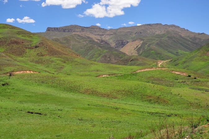
Scenic route over the southern Drakensberg to Letsie Lake

Qacha's Nek is a commercial border post,  35 km from Matatiele. Unfortunately, despite its busy status (open from 7:00 to 20:00) and used mostly by tourists and tour operators, it is also on the end of a bad gravel road that will take an hour to complete from Matatiele. 

We crossed the border here on a rainy morning to travel the very scenic route in Lesotho to Ramatseliso, the next border post. The first 10 km is a perfect tarred road through the Qacha's Nek village. The A4 gravel road to Ramatseliso is a good gravel road across many mountains, rivers, and valleys.

On our way to Qacha's Nek from Matatiele
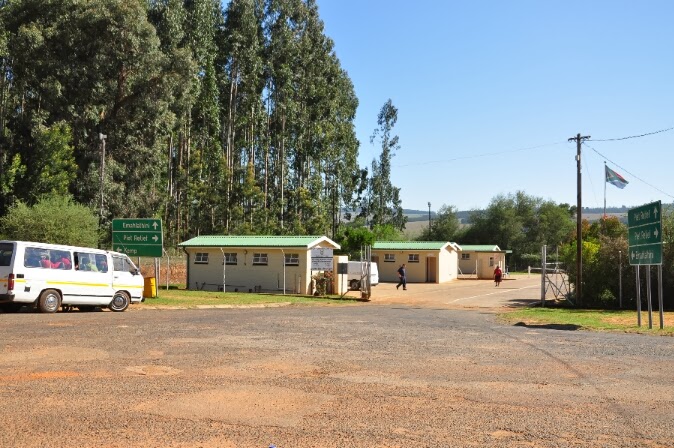
Full-blown commercial border post at Qacha's Nek
We paid R30 toll fee on the Lesotho side
Scenic road in Lesotho from Qacha's Nek to Ramatseliso

Ramatseliso' Gate border post is only 45 km from Matatiele. At an altitude of 2285 meters, it is the highest border post in South Africa. Only border police staff are present and they do the immigration duties. The last 6 km of the 'road' on the SA side is in a terrible condition and only recommended for 4x4 vehicles. 


Only the brave (probably with quad bikes or serious 4x4 vehicles) will attempt the border post from the SA side.  Most tour operators come from the Lesotho side. That is also what we did, and although a bit nerve testing at places and the pouring rain, we slowly went down the pass without incident. The weather did not allow us to take many pictures. Congratiolations to Esti from Capitec who followed us in a SUV 2x4 vehicle with which she had no similar experience - well done!

Ramatseliso's Gate border post on Lesotho's side
High altitude mist and rain


You can read an article by Toast Coetser in the November 2013 issue of WEG / GO magazine about all the mountain scenery around Matatiele.
Tuesday, 5 November 2013

Piet Retief's access to Swaziland

Piet Retief is a town in Mpumalanga on the N2, south west of Swaziland. It is surrounded by pine and bluegum wood plantations. There are 3 border posts to Swaziland, all three within 100 km from the town.

Emahlatini (Sicunusa on Swaziland's side) is the closest of the three border posts and only 21 km out of town. It can be reached by a tar road, but sad to say, the road is in a terrible condition. Pot holes force you to drive more alongside the road than on it. The local farmers attempted to fix the road but was prevented by the provincial government from doing so. It appears as if there is no intention from the Mpumalanga provincial government to fix the road soon. A real shame and slap in the face of all tax payers from this area.

The tarred road on the Swaziland side leading to Manzini, is in perfect condition. Many tourists use this border post as a quick access to the lowveld or Mozambique. Locals from Swaziland also frequent this border post to do their shopping in South Africa, adding to the average of 25,000 people crossing here per month. No commercial traffic can be accommodated as there is no SARS or custom facilities. The border post opens only at 8:00 and closes at 18:00 every day.

Bothashoop is 30 km from Piet Retief and the smallest of the three border posts. It can only be reached by gravel road, which is in a better condition than the tar road to Emahlatini. It is a small border post, but extremely neat and tidy with friendly staff. They are the proud owners of the floating trophy for the best border post to Swaziland. 

About 100 to 200 locals from Swaziland per day are the principle users of the border post, operating from 8:00 to 16:00. They are dropped by taxi/bus on the Swaziland side (called Gege) and then collected by bus/taxi on the SA side. The same procedure is followed when they return to Swaziland.

Mahamba is the bigger, and only commercial, border post of  the three. It is 35 km from Piet Retief and can be reached via the tarred R543 in good condition. The post is operational from 7:00 to 22:00 and has the same name on the Swaziland side.

We crossed the border here into Swaziland, but even so, could not find a friendly staff member to get more information. It is however, a very modern border post. Our crossing and declaration of cameras and laptops were processed electronically - very efficient and impressive.

The roads on the Swaziland side were in an equally good condition. The border post can be recommended for quick access to the lowveld or Mozambique.

Taxis collecting pedestrians from Swaziland at Emahlatini 
Swazi people arriving at Emahlatini

Nice gravel road from Emahlatini to Bothashoop
A bus waiting for pedestrians from Swaziland at Bothashoop
Bothashoop, the clean and tidy border post with Gege on the Swaziland side
Joining the R543 to Mahamba
Good tar road leading to Mahamba border post

Entrance to Mahamba border post
Mahamba on the Swaziland side
Excellent road in Swaziland after entering at Mahamba

Nerston - from the Swazi side

We crossed into Swaziland at the Ludzi border post (Waverley on SA side) where we had to pay a R50 'tollfee'. The first 15 kilometers are on gravel roads through pine forests before we reached Bhunya, a reasonable town. From here it is another 30 km tarred road before we reached the Sandlane border post.

The road is not in a good condition and it is not clear what is being done with the 'toll fee' we paid. Perhaps for future use (or used elsewhere as we later discovered).

We re-entered South Africa again through the Sandlane (Swaziland's side) and Nerston border posts, only 30 km south of Waverley, without any hassle or incident. Although Nerston is a commercial port of entry with SARS and custom officials present, it is very quiet. It is mainly locals and migrant workers from Swaziland that cross the border here between 8:00 to18:00.

From Nerston it is only 20 km to Amsterdam on the R65, a tarred road in good condition.

Scenic gravel road on the Swaziland side
Tarred road near Bhunya in Swaziland. Pot holes not shown here.
Re-entering South Africa at the Nerston border post


Waverley - quiet contrast

Waverley border post to Swaziland is only 30 km south of the Oshoek border post and slightly higher at an altitude of 1580 meters. It is a quiet, non-commercial border post used mainly by locals from the area on both sides. Operational hours are 8:00 to 16:00.

The border post can be reached via tarred roads from the N17 (about 120 km from Ermelo), but we took a gravel road from Oshoek, passing through Glenmore, a small rural settlement. The 30 km road goes through and over several mountains and forest plantations, again not always shown on any map we had.

We decided to cross the border at Waverley and drive through Swaziland to the next border post. Concerned about the meat, fruit and vegetables we have, we asked the officials what will happen when we re-enter South Africa. They inspected our vehicle and assured us it would not be a problem as we could prove it was bought in South Africa for own consumption. If it was not the case, we would have to go back to Oshoek to get customs, SARS, and agricultural clearance.

We crossed the border and was received by the friendly staff at Lundzi, the Swaziland side of the border post. There are no major roads or towns close to Lundzi on the Swaziland side. It is mainly pinetree forests with small gravel roads leading to Bhunya about 20 km away.

I will report on this excursion in the next post about Nerston border post.

J
Gravel road to Waverley - mountains and forests
Passing through rural settlements towards Waverley border post
Entering Waverley border post from SA side
Lundzi, border post on the Swazilandd side

Tuesday, 15 October 2013

Bray - goeie mense, maar slegte paaie


Van Makopong is dit so 100km Oos na Bray, die Kalahari 'hoofstad' op die grens met Botswana, teen die Molopo rivier. Hier is hartlike, goeie mense en baie interessante karakters. Dis ook in die omgewing waar Frik du Preez tot so 7 jaar gelede geboer het. En eenkeer 'n jaar, in Junie, is die 'Bray July' perde wedren 'n groot gebeurtenis.

Maar die mense van Bray het rede om baie ongelukkig te wees met hulle owerhede. Al die toegangspaaie is in 'n swak toestand. Ek dink nie 'n gewone sedan motor sal Bray kan bereik sonder om vas te sit in die Kalahari sand nie. Die paaie word eenvoudig net nie in stand gehou nie. Beloftes dat die teerpad van Tosca, wat 40km voor Bray eindig, tot in Bray verleng gaan word, begin nou al lank in die tand raak ...

Maar reisigers wat wel in Bray aankom, kan uitsien na goeie verblyf by die Tapama Lodge. Ons was gelukkig om op 'n Sateragaand hier oor te bly. Die omgewing se boere met hulle gesinne het van ver gekom. Daar was Curriebeker rugby op die 'big screen'. So nou en dan is die klank onderbreek om 'n Afrikaanse treffer video te speel. Die braaivleis vuur in die groot lapa word gestook van 'n groot stapel Kalahari doringboom hout. Die Blou Bulle verloor teen die Cheetahs en 'n paar van hulle ondersteuners gaan sit eerder buite en stry oor 'Ford of Cruiser' bakkies.

Gert en Annemarie van Rensburg is die eienaars van Tapama Lodge. Gert boer ook met beeste op 'n plaas so 100km buite Bray. Annemarie werk bedags in die hospitaal, maar die aand het sy ons 'T-bone steaks' voorberei terwyl Gert die kroeg beman het. Die netjiese chalets by Tapama Lodge is nie selfsorg nie. Die lodge bied  alle etes en naweke (volgens 'n kennisgewing bord) verander dit in 'n 'pub and grill'. Daar is ook kamp geriewe met 'n baie skoon en gerieflike ablusie blok. Welkome en uitstaande geriewe vir die wilde Kalahari.

Gert wys ons die artikel van Toast Coetser wat in die Weg van Julie 2008 verskyn het. Dit het gegaan oor 'n man wat hier in Tapama Lodge op sy kop gestaan het en 'n glas bier 'ge-down' het. Toast het dit blykbaar aanskou, so ek  glo dit ...


Die paaie na Bray is geskik vir die voertuie

Dit gaan jolig in Tapama Lodge se kroeg


Gert (eienaar Tapama Lodge) vertoon sy Capitec kaart vir die borge


Sunday, 13 October 2013

McCarthy's Rest - border post no 15 of 72

From VanZylsrus we travelled 30km North on a gravel road towards the Molopo high-way (see one of  the previous posts under Roads). We followed the Molopo river for 90km towards McCarthy's Rest border post. 

This is a beautiful gravel road, but not if you are in a hurry. Firstly there are 17 farm gates to open and close. You  also have to watch out for Steenbok,  Ostriches, and especially holes dug by Aardvarks in the middle of the sandy jeep track. It took us 3 hours to reach the border post. There are faster roads such as the one from Hotazel.

The border post is used by tourists on their way to Mabuasehube, the Botswana part of the Kgalagadi Transfrontier Park. Tshabong is only 25km away on the Botswana side, the last town before reaching the park. Locals cross the border here for events such as funerals  and weddings. There are not a lot of commerial traffic.

The sandy jeep track along the Molopo river

McCarthy's Rest border post - SA side


Friday, 11 October 2013

Molopo high-way

After entering South Africa at Gemsbok border post, our next border post on the tour is Middelputs, about 180km east. There is more than one road that will take you there, some faster than others. We wanted to stay as close as possible to the border, and that, according to most maps, is to follow the Molopo river. 

We found the turn-off just before the little town of Molopo. The border post officials could not understand why we want to use this road ...

The only indications of a river along this road are on the road maps and the twisting road. On my Garmin GPS, the road on the South African and Botswana side, as well as the 'river' appear as one and the same purple line. So the roads are in the river. A policeman at Middelputs later told us that this river was in flood in 1974 and 1988. But today this is a dusty, sandy road. Do not use it if you are in a hurry (there are 15 farm gates!) or when it did rain.

The first 40km is the worst. It is a normal sized gravel road, but very sandy where you expect it the least. At places I was thinking that the sudden soft sand holes will take the spare wheel of the Toyota Hilux off. After the first 60km it becomes a single jeep track, but much better than the first part. This is where we started counting the 15 farm gates... The 160km from Gemsbok to Midddelputs took us more than 3 hours to complete - but once again, well worth the effort.

On the opposite side in Botswana, a mere 10 meters away is a new tarred road (the B211). According to the locals, this provides a nice alternative route for travellers from Gauteng to the Kgalagadi.

15 farm gates on the Molopo high-way

Molopo high-way on the right, Botswana tarred B211 on the left - border in between

Wednesday, 9 October 2013

The road to Noenieput

Noenieput used to be a border post to Namibia, mainly for Namibians who schooled their children in South Africa. It stopped operations in 2007 due to low volumes of traffic. We wanted to see what it looks like and took one of the (longer) gravel roads to get there. 

The second turn-off to Noenieput, 70km from Upington on the R360, took us onto a gravel road through red sand dunes. Typical Kalahari scenery. We reached Noenieput 80km and 11 farm gates later! 

Noenieput is a small village right on the Western border of South Africa with Namibia. There are only 7 permanent homesteads in town and no electricity. Those who need electricity must generate it themselves. However, there is a MTN cell phone tower.

We were desperate for an ice cream but no luck due to the lack of electricity. There are two shops: a general dealer and the local agricultural co-operation.


Sunday, 6 October 2013

Dag 5 Saterdag 5 Okt - week se hoogtepunt

Die kampeerplek by Aquacade is definitief een van die beter kampplekke waar ons al was. Vroegoggend ry ons weg van Vioolsdrift. Ons volg die N7 tot so 20km voor Steinkopf waar ons links afdraai op die eerste moontlike grondpad. Die bord wys Henkries. Ons wil Pella se rigting na Pofadder.

Ons volg die Garmin City Navigator Pan-Africa se kaart op die GPS. Kort-kort draai ons weer af tot ons op 'n plaaspaadjie deur 'n verlate, sanderige grasvlakte ry. Dit is 'n baie lekker pad om te ry en ons voel eintlik teleurgesteld toe ons later weer op die 'groot grondpad' naby Pella uitgespoeg word.

Onseepkans se grenspos is ook 'n hoogtepunt (sien volgende inskrywing).


Day 4 (4 Oct) - 4x4 to Vioolsdrift

There are'nt any shortcuts from Sendelingsdrift to Vioolsdrift, except a 4x4 route of about 140km. We decided that is the way to go. This road goes via Kuboes to Eksteenfontein.  Nice gravel road with a few hilly, rocky sections here and there. About 7km past Eksteenfontein we left the gravel road onto a jeep track towards Kotzeshoop. 
There are not many roads like this left in South Africa, accessible for everyone with a high-clearance vehicle and time to travel. The 140km took us 4 hours to Vioolsdrift, but well worth the effort.
After doing our duties at the border post with relative ease, we set up camp at Aquacade, 10km from Vioolsdrift next to the Gariep river. Beautiful setting and a nice place to catch up on my blog posts. 


Friday, 4 October 2013

Dag 3 - eerste grenspos per pad

Van Port Nolloth is dit maar 'n eentonige reguit teerpad tot by Alexanderbaai. Die pad is wel in 'n baie goeie toestand. Die grenspos is so 5km uit die Alexanderbaai, op die Garieprivier se oewer. Dit was stil daar en die vriendelike personeel het ons graag ontvang. 

Die plan was om vandaar aan SA se kant na Sendelingsdrift te ry. Maar nadat ons uitgevind het daar is 'n bruikbare pad aan Namibie se kant, besluit ons om eerder so te ry. Flink en effektief gaan ons deur die grenspos en oor die Ernest Oppenheimer brug. 

By Oranjemund (grenspos aan Namibie se kant) is dit nie so effektief nie. Hier moet alle inligting nog op papier vorms voorsien word. Dit is hier net so stil, en glo dit, geen inspeksies, oorgrens fooie, voertuig belasting of vesekering nie. Dalk 'n glipsie, of 'n 'loophole' ...
Die grondpad van Oranjemund na Sendelingsdrift is soos meeste grondpaaie in Namibie, in uitstekende toestand.  Ons ry die 90km in 'n japtrap al langs die Garieprivier tot by Sendelingsdrift. Hier gaan ons met die pont oor, terug na Suid-Afrika. Vanaand kamp ons in die Richtersveld nasionale park by Potjiespram kampterrein.

Wednesday, 2 October 2013

Day 2 - tar roads can be misleading

There was no border post to be visited today as we managed to visit Saldanha Bay on day 1. We headed north towards Alexander Bay and tried to avoid the N7 as much as possible. 

From Jacobsbay we took the roads as close to the West coast as possible, passing Elandsbay, Lambertsbay, Strandfontein using Transnet's toll roads (fee = free). Just a few kilometers from Strandfontein we took a short detour to the mouth of the Olifantsriver.

From Lutzville we wanted to go to Nuwerus where we would join the N7 again. However, a tar road next to a water pipeline appeared to be the better road. We ended up at Namakwa Sands mine with no more roads except farm roads through Namaqua land. 

We passed Lepelfontein and Kotzesrus, two very small villages, before reaching Garies much later than anticipated. This was a real gravel road, in line with DriveOut's motto, and not on a GPS or printed map. But Namaqua land had lots of rain and the scenery compensated for the longer drive. 

Tomorrow we drive from Port Nolloth to Alexander Bay, the first road border post on our trip.  

Apologies for the lack of pictures - we focussed so much on the road that we completely forgot to take pictures for this blog!