Thursday, 21 November 2013

Mission completed - what now ?

Our tour to visit all the South African ports of entry started on 1 October and was completed 50 days later on 19 November 2013. We visited 73 ports of entry and documented all the relevant information about these ports.

But the ports were just beacons along an amazing journey through our beautiful country. We travelled on all kinds of roads, mostly gravel roads, experienced breath taking scenery, met extraordinary people, and stayed at wonderful places.

All of this will now be processed and presented to our main sponsor, the WegRY / Driveout travel magazine. They will decide how and when it is used, most probably not earlier than the March 2014 editions of the magazines.

In the meantime I will complete, correct, and extend this blog as best I can. I appeal to you to present me with any information related to the topics I have covered. If you have specific information such as:

  • Origin of the name of a border post
  • Historic reasons why border post was established at the specific site
  • Date of first use as a border post
  • Corrections to information I have mentioned about a border post
  • Any special experience encountered at a border post

Please forward this to me by commenting on this post. All comments are directly emailed to me and I will be in touch with you. I will acknowledge all valuable contributions.

Thanks for following our tour on this blog. The response was surprising and made the tour so much more rewarding. I hope to have a similar privilege again soon.

Johan Rothmann
johanrothmann@gmail.com

Mosselbaai - lekker plek om af te sluit

Mosselbaai is in November 2013 aangewys as die "groenste" munisipaliteit in die Wes-Kaap. Die dorp spog ook met die "beste" gemiddelde weer dwarsdeur die jaar. Tel daarby die pragtige baai wat al in 1488 deur Bartholomeu Diaz raak gesien en gebruik is, en jy wonder hoekom bly almal nie hier nie.

Die hawe bedien sedert die vroegste dae van die Hollandse settelaars die Suid-Kaap en Klein-Karoo. Meer as 800 ton volstruis vere is jaarliks deur die hawe uitgevoer tydens die bloei tydperk van die volstruis bedryf. 

Tydens ons besoek was daar 'n Duitse plesier boot in die hawe. Die toeriste word toegelaat om die boot te verlaat en met behulp van spesiale identiteitskaarte toegang na die dorp te kry. Geen immigrasie beheer word in so geval toegepas nie. Immigrasie amptenare van George word wel ingeroep wanneer onwettige immigrante deur die polisie in hegtenis geneem word, voordat hulle in die hof moet verskyn, of wanneer skeeps bemanning vir langer tye aan wal gaan.

Hawe sekuriteit is streng en ons kon net op 'n afstand na die aktiwiteite kyk. Dit was egter 'n paslike afsluiting van die 73 grensposte wat ons tydens die toer besoek het.

Streng sekuriteit by die hawe se ingang

Duitse plesierboot in Mosselbaai hawe


Wednesday, 20 November 2013

Port Elizabeth - not a friendly experience

After the nice visit to the harbour and airport of East London, we continued our journey along the coast towards Port Elizabeth. 

Along the way we stayed over at Green Fountain Farm Resort, just before Port Alfred. Amazing place, owned and managed by amazing people, Rob and Frieda Greyling. Look at www.greenfountainfarm.co.za for more information.

First port of entry on our agenda for the day, was Port Ngqura, 20 km north of Port Elizabeth. The harbour is situated at the mouth of the Coega river. It is part of the plans of the Coega Development Corporation and is South Africa's newest harbour. This first commerial cargo ship moored here in October 2009. The harbour was officially opened on 16 March 2012.

But that is about as far as we got here. Despite numerous attempts at various offices and gates, we could not get more information or pictures, and did not gain entry into the harbour area. We were invited to submit a written request to visit  the port, which will then be proccessed within 48 hours - not suitable for our tour ...

Road entrance to Port Ngqura
Permits required to gain entrance here
Coega Development Corporation - burocratic red tape galore! 

At Port Elizabeth Harbour, South Africa's third biggest after Durban and Cape Town, we had a similar experience with no better luck. Transnet's access control was strictly enforced and we could not see much nor gained entry or access to information. We were told that when luxury cruise liners visit the harbour, the general public is allowed access with little control over cameras. Despite this, I could not convince them to allow us similar access.

Port Elizabeth harbour - no entry here
The word 'Welcome' has different meanings for different people


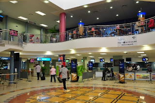
Port Elizabeth International Airport, previously known as the HF Verwoerd Airport, gave us a more welcome feeling. The staff at the information desk were eager to provide us with all the information we needed or to introduce us to the right people.

There are no sheduled international flights to/from Port Elizabeth. When international passengers do arrive on chartered or private flights, the immigration staff (based in town) will be called out to process their airports. Most of the domestic airlines offer scheduled flights to and from all the major centres of South Africa.


East London - the friendly little city

After reaching the top of Sani Pass, the last of our border posts by road, we headed south along the coast to complete the tour with the last harbours and airports. First stop was East London. We experiened it as a clean, friendly city, not too big and not too small either.

The unique harbour 'in' the mouth of the Buffalo river, South Africa's only river harbour, has international status. This is mainly due to the international cargo ships serving the motor industry, specifically Mercedes Benz, whose manufacturing plant keeps this city alive. Ships with a capacity of 5,000 cars can often be seen leaving the harbour. Its not only motor cars though, as the port also boasts the biggest export grain elevator of all SA ports.  

Immigration officials from the Dept of Home Affairs are based in town. They are called out when crew from international ships want to disembark, or when the occasional cruise ships visit the harbour.

There are plans to establish a waterfront boardwalk with restaurants and other entertainment on the eastern side of the harbour. This can only make East Londen more attractive.


Eastern side of East London harbour


Looking at the western side of East London harbour - for the motor industry
Waterfront development planned for this section of East London harbour

East London airport, only 10 minutes drive from the harbour, was previously known as the Ben Schoeman Airport. After the democratic elections in 1994, it was renamed to East London International Airport.

The airport is neat and tidy and quite busy on the Sunday morning that we were there. There are daily domestic scheduled flights by SA Airlink, SA Express and Kulula to all the major centres of South Africa. No scheduled international flights, and according to the airport manager on duty, and much to our surprise, it has no immigration processes to deal with international passengers. I will certainly verify this as it is listed by the Dept of Home Affairs as an international airport. 


The signage does not display 'International' status


East London is also known as Buffalo City

Tuesday, 19 November 2013

Sani Pass - we finish on a high

Sani Pass border post to Lesotho is the last border post by road on our tour. So much has been written about this major tourist attraction in southern KwaZulu-Natal, that I can only conclude with the current state as we found it.

The SA side of the border post is 33 km from the scenic town of Himeville. The first 21 km is on a newly built tarred road in perfect condition, followed by 12 km gravel road that gives you just a feeling of the pass which is about to follow. Once you have stamped your passport at the SA border post, the last 9 km of the actual Sani pass starts towards the top where the Lesotho border post is situated. There were rumours that this part of the pass will also be tarred, but for now it is not. Up to 40 4x4 vehicles from tourist operators ascent and decent the pass daily. The gravel road is well maintained and most 4x4 vehicles will have no problems to reach the top. There are steep sections and sharp bends, but the unsurpassed scenery will remain in your mind for a long time.

Once you reach the top at an altitude of 2880 meters, you have to visit the Lesotho border post to get your passport stamped and pay a R30 toll fee. You are then free to visit the highest pub in Africa (200 meters away) and celebrate the experience before attempting the decent.

The new tar road leading to Sani Pass
The gravel road before the SA border post
The SA border post before the start of the real Sani Pass
The Lesotho border post at the top of the Sani Pass
View from the top on a cloudy day
A scenic decent

Bushman's Nek - pedestrians crossing here

Bushman's Nek border post to Lesotho is situated on the border of the World Heritage site of the Southern Drakensberg, 40 km from Underberg in KwaZulu-Natal. The 23 km gravel road leading to the border post is in good condition but can be slippery when wet (as when we visited).

Once again (third border post now) there is no border post on the Lesotho side. It is manned by border control police only - no immigration officials. But this border post has another unique feature: there is no road on the other side into Lesotho. You can only cross the border here on foot, or on the back of a donkey or horse. It will take approximately 8 hours to cross the Drakensberg into Lesotho.

The border post was started as an entry into South Africa for Lesotho people to come and sell their sheep wool or trade it for maize. It is still  the case today, although much less so. It is a beautiful border post in a beautiful area, but very quiet during the 8:00 to 16:00 operational hours.

Bushman's Nek - World heritage site
Bushman's Nek border post
The road to Lesotho - no road further ...
Look carefully for the donkey waiting to enter South Africa


Saturday, 16 November 2013

Matatiele - scenic drives to 3 border posts

Matatiele is a vibrant town in the Eastern Cape on the R56 road between Kokstad and Maclear. The R56 is described as a shorter and safer alternative to the N2 between KZN and the Cape. 

There are 3 border posts from South Africa to Lesotho within 70 km from Matatiele. It is often used as a scenic route for tourists to visit all 3 in a circular route from Matatiele through Lesotho. No one better than the local tourist guide, Philip Rawlins, who will gladly assist with route planning, road conditions, tourist attractions, and even excursions in his Cruiser 4x4. Philip is also the owner of Resthaven Guesthouse in Matatiele which I can recommend for good accommodation and real good food.

Ongeluksnek Border post is 65 km north-east of Matatiele, inside the Eastern Cape Park, Ongeluksnek Nature Reserve. The 55 km gravel road leading to the border post is rough and it will take you more than an hour to reach the border post. There are only police staff present, no immigration officials. This is the second border post to Lesotho that we encountered where there is no border post on the opposite side. 

As can be expected, it is a quiet border post used mainly by 4x4 enthusiasts, tour guides, and a few locals crossing the border by foot. There are often days, or even weeks, that no one crosses the border here during the 7:00 to19:00 operational hours.

There is a nice 4x4 road crossing the southern Drakensberg into Lesotho. One of the first scenic attractions in Lesotho is Lake Letsie, 7 km from the SA border post.


Entrance to the nature reserve before the Ongeluk's Nek border post
Ongeluk's Nek border post
Exit the SA side, but no border post on the other side
Scenic route over the southern Drakensberg to Letsie Lake

Qacha's Nek is a commercial border post,  35 km from Matatiele. Unfortunately, despite its busy status (open from 7:00 to 20:00) and used mostly by tourists and tour operators, it is also on the end of a bad gravel road that will take an hour to complete from Matatiele. 

We crossed the border here on a rainy morning to travel the very scenic route in Lesotho to Ramatseliso, the next border post. The first 10 km is a perfect tarred road through the Qacha's Nek village. The A4 gravel road to Ramatseliso is a good gravel road across many mountains, rivers, and valleys.

On our way to Qacha's Nek from Matatiele
Full-blown commercial border post at Qacha's Nek
We paid R30 toll fee on the Lesotho side
Scenic road in Lesotho from Qacha's Nek to Ramatseliso

Ramatseliso' Gate border post is only 45 km from Matatiele. At an altitude of 2285 meters, it is the highest border post in South Africa. Only border police staff are present and they do the immigration duties. The last 6 km of the 'road' on the SA side is in a terrible condition and only recommended for 4x4 vehicles. 


Only the brave (probably with quad bikes or serious 4x4 vehicles) will attempt the border post from the SA side.  Most tour operators come from the Lesotho side. That is also what we did, and although a bit nerve testing at places and the pouring rain, we slowly went down the pass without incident. The weather did not allow us to take many pictures. Congratiolations to Esti from Capitec who followed us in a SUV 2x4 vehicle with which she had no similar experience - well done!

Ramatseliso's Gate border post on Lesotho's side
High altitude mist and rain


You can read an article by Toast Coetser in the November 2013 issue of WEG / GO magazine about all the mountain scenery around Matatiele.

Thursday, 14 November 2013

Wildside Riverside Camp

After leaving Tele Bridge border post, we took the Lundeans Nek mountain pass towards Rhodes.This is the Eastern Cape Highlands and there are a number of mountain passes that will take your breath away.

We heard about Wildside, a riverside camp between Barkly-East and Rhodes and wanted to spend a day, and maybe two, there. I read the (good) directions from the website the previous evening, but we got lost because of my bad memory. We arrived at the camp site just before sunset. What a beautiful setting!

Wildside is a remote, quiet, tranquil campsite, next to the Kraai river which is one of the sources of the Gariep river. There are 6 spacious camp sites on the river bank, uniquely bordered with stacked wood, plus two luxury safari tents with ensuite facilities. There is no shortage of firewood and guests are encouraged to pick up wood from the surrounding forest floor!

Wildside is one of the ventures of Phil Harrison and Kate Nelson. Phil, a FGASA Level 3 field guide, lives at Wildside. He can organise and guide various adventures such as mountain biking, river rafting, trout fishing, hiking, customised to your requirements.

The residents dogs, Shadow and Gypsy, will steal your heart. They live in paradise and you can see the joy in their endless energy and playfulness.

We stayed for two nights and wished we had more time. We left rejuvenated.

www.wildmountainadventures.co.za

Spacious campsites with firewood galore
Safari tent with ensuite facilities

Central space between safari tents and camp sites
Scenic Kraai river


Tele Bridge - well done Lesotho!

It is not often that one of South Africa's bordering countries can boast with a more modern border post than that on the SA side. Tele Bridge border post to Lesotho is an exception.

We approached Tele Bridge from the Lesotho side after having crossed at Sepapu's Gate earlier in the day. It was a good drive on the A2 tarred road up to the last 10 km on a good gravel road. 

We were surprised to see the very modern buildings that were opened in 2011. All the entities comprising a commercial border post are present: income tax, customs, police, even a health department.

It is an impressive bridge over the Tele river that leads you to the South African border post. Surprisingly, it is not a commercial border post despite the status on the Lesotho side. The buildings are relatively new and in good shape, but this time the prize for the best border post goes to Lesotho!

The daily average of only 300 people that use this border, the relatively long operational hours of 6:00 to 22:00, and the big and modern facilities on the Lesotho side is hard to understand. Is this tax payer's from SA and Lesotho money well spent?


Most modern border post building we saw in Lesotho 


Bridge over the Tele river

Makhaleng Bridge - bad roads lead to declining numbers

Makhaleng Bridge border post is 40 km from Zastron in the south-eastern Freestate. The border post can only be reached by gravel roads from the SA side. Unfortunately these gravel roads are in a terrible condition and most travellers will avoid them at all costs.

We approached the border post from the Lesotho side via the A2 tar road in a good condition. The last town before reaching the border post is the neat and relatively modern Mohales Hoek, about 10 km away.

We asked the Lesotho officials if we can cross the bridge over the Makhaleng river, to the SA side. They had no problem, so we crossed the bridge as many pedestrians do at this border post. 

It is mainly locals from either side that are still using this border post. The bad roads on the SA side had a definite impact on the number of people crossing  the border here. 

Pedestrians crossing the bridge over the Makhaleng  river, into South Afica
Entering the SA side of the border post
We saw this sign alot in Lesotho, but never had to pay any  toll fees